Reg No. - CHHBIL/2010/41479ISSN - 2582-919X

India Backs UN Map Reform, Draws Red Line on J&K and Ladakh
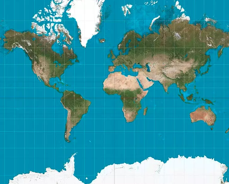
A world map illustrating the global landmasses. India has supported a UN resolution encouraging equal-area map projections while insisting that Jammu and Kashmir and Ladakh must be depicted in accordance with India’s official map. (Representational)
New Delhi supports equal-area world-map projections but says any inaccurate or misleading depiction of India’s sovereign territory will be unacceptable
New Delhi: India has backed a United Nations initiative aimed at correcting distortions in conventional world maps, while making it unequivocally clear that the Union Territories of Jammu and Kashmir and Ladakh must be depicted in accordance with India’s official map.
The clarification came after India voted in favour of a UN General Assembly resolution seeking greater use of equal-area map projections, which are intended to represent the relative sizes of continents and regions more accurately.
The resolution, “Correct the Map: Rebalancing Global Cartographic Representation and Promoting Equitable Representation of the World’s Regions, Particularly Africa,” was adopted by the UN General Assembly on September 4. It was sponsored by Togo and received 164 votes in favour. The United States voted against it, while six countries — Estonia, Georgia, Lithuania, Moldova, Serbia and Ukraine — abstained.
India Separates Map Projection From Sovereignty
External Affairs Ministry spokesperson Randhir Jaiswal said India’s support for the resolution was based on the principle of promoting equal-area cartographic representation and should not be interpreted as approval of any particular political map or depiction of international boundaries.
“India voted in favour of the resolution and also made an explanation of vote stressing on the underlying principle of promoting equal-area cartographic representation,” Jaiswal said.
He emphasised that the resolution does not amount to UN endorsement of any particular world map, projection or representation of national boundaries.
For New Delhi, that distinction is critical because an initiative intended to correct the relative geographical size of continents cannot, in India’s view, become a vehicle for altering or misrepresenting its territorial claims.
“India’s sovereign territory, including the Union Territories of Jammu and Kashmir and Ladakh, must be depicted in accordance with India’s official map. Any inaccurate or misleading depiction is unacceptable,” Jaiswal said.
He further underlined India’s established position on the issue.
“Our position on India’s sovereignty and territorial integrity is clear, consistent and non-negotiable,” he said.
What the UN Resolution Seeks to Change
The debate concerns a long-standing problem in cartography. Some commonly used world-map projections distort the apparent size of landmasses because representing the curved surface of the Earth on a flat map inevitably involves compromises.
The new UN initiative encourages the use of equal-area projections, which preserve the relative area of different regions more accurately. Africa has been central to the debate because conventional maps can make the continent appear substantially smaller in relation to some northern landmasses than its actual geographical area would suggest.
Jaiswal stressed that the scope of the resolution is cartographic representation rather than territorial adjudication.
“The purpose of the resolution is to encourage the use of equal-area map projections that preserve the relative sizes of continental landmasses,” he said.
He added that the resolution neither adopts nor authenticates a particular world map and does not deal with political cartography involving international boundaries, disputed territories or place names.
That clarification enables India to support the broader objective of improving geographical representation while simultaneously maintaining its position that its internationally presented territorial boundaries must conform to the country’s official map.
Geography and Geopolitics Remain Separate
India’s position consequently draws a distinction between two very different questions: how large countries and continents appear on a world map, and where national boundaries are drawn.
New Delhi has supported the first objective but made clear that the second cannot be altered through an initiative dealing with map projection.
The qualification assumes particular significance for Jammu and Kashmir and Ladakh, where cartographic representations used internationally have periodically drawn objections from India.
India’s vote therefore combines support for more geographically representative global cartography with an explicit reservation on sovereignty: correcting distortion in the size of the world’s landmasses, New Delhi maintains, cannot mean redrawing India’s territorial representation.

YOU MAY LIKE THIS